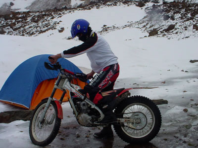
The North Calcutta Disha, a motorcycle club from Calcutta (obviously) who had previously set the Guinness record back in 2008 at 6,245m, before we topped that in 2012 with 6,361m, responded to having Guinness recognise Gianfranco Bianchi as the new moto record holder in 2015 with 6,471m with a new plan. In 2016 the Disha went to Chamser Kangri in Ladakh to set a new world record.
Now they claim to have summitted Chamser Kangri but the photo and video evidence in what they have released is a little disappointing to say the least and raises more questions than it answers. There is no distinctly recognisable summit photo nor a 360 degree video to show there is nothing in the vicinity higher which would confirm the summit. Chamser Kangri is regarded as being 6,622m (21,726 ft) high, so clear evidence of GPS location and nothing in the immediate vicinity being higher would be pretty good evidence. But for some reason, in 2016, they dont seem to have taken a recognised GPS unit (Garmin obviously prefereable) when going for a world record. To me thats just madness and asking for controversy. (Unless they did take a GPS unit and don't show it as it doesn't tell the story they want - after all every smartphone contains a GPS receiver). They have put out a video where the standout for me is that there is precious little in terms of evidence. The two items in their video that are supposed to be the evidence are screenshots I will display below. One is a watch with a digital reading saying "21524 ft" and the other is some sort of electronic device with a blank screen.
.png)
.png)
Obviously when putting out a video evidencing your claim then the best pieces of evidence you have will go into that video. So this is clearly the best evidence they have.
The device with a blank screen (or at least no visible screen readout) is not meaningful at all. In itself it does not demonstrate anything apart from ... this is where we got to... this is where we stop to take pictures of how high we got and to try and shoot the evidence.
The watch with the digital readout, initially seems useful as evidence, until you look into the watch. It is Timex WS4 Expedition watch. It has a barometric pressure meter in it, and uses that to infer altitude. It is not an accurate altimeter. Further, as anyone who watched the weather will tell you, barometric pressure at sea level varies +/- 5% subject to the weather. That translates to huge errors in interpreting altitude. It is also worth noting that the primary reason the barometric pressure sensor is in there in this watch is not as an altimeter at all. It is to provide a history of changes in pressure to predict when a storm may hit mountaineers or when weather is on the improve.
A quick review of the accuracy of barometric altimeters in Timex watches can be found here: http://4alloutdoors.org/reviews/timex-ws4-expedition-watch-3/. The author of that article, who hikes up to around 3000 feet, found the watch to be within 70 feet of the various reference point altitudes. Plus or minus 70 feet in 3000 feet is a +/- 2.3% error. At 6500 metres, that is a 150 metres (500 feet) inaccuracy range. The reality is barometric altimiters are wildly inaccurate if not correctly calibrated, and can be completely inaccurate if the user deliberately calibrates it to read falsely (i.e. calibrates it to read high). Barometric pressure changes daily, or even hourly. A barometric altimeter needs to be calibrated frequently to adjust the altitude it think it is at. The fact that it is designed to be calibrated frequently also lends it to to be easily deliberately miscalibrated.
So just to summarise the only piece of altitude evidence they have, the only altitude reference the Disha got is NOT a GPS based altitude. It is an air pressure based altitude, not with a certified altimeter, and with no evidence of the altimeter being calibrated to match an actual known altitude the morning the group set up the mountain (because air pressures change all the time, a barometric altimeter needs to be recalibrated every hour or so either to known fixed elevations or to known sea level air pressures in the location they are at). The guys recently reported days of rain before they went up the mountain. Rain is associated with low barometric pressure. Low barometric pressure would make a barometric altimeter think it is higher than it actually is. (air pressure is lower when it rains, just as it is lower at altitude). Further the altimeter, which again is the only piece of evidence they have about the altitude they reached, is subject to being easily manually calibrated to deliberately over-read or incorrectly inflate the altitude it is at. i.e. there is only one piece of evidence and it is easily rigged! There is just too much vague and foggy and questionable here.
And that leads me to the next point. In 2008 when the Disha got a world record, they had their altitude of 6,245m verified by the Indian Army. [Guinness obviously must now be aware of the Indian Army's penchant for being dishonest about altitude (the Indian Army has recently put its name to a NEW sign on Khardung La again falsely claiming it to be 5,602m / 18,380 feet when the entire world knows it to be 5,359m {17582 ft})].
.png)
For this 2016 attempt, I don't know what evidence they sent into Guinness, but it is clear that Guinness did not approve of it. If they are putting this video out now to justify their claim then it is hard to believe Guinness saw any more than we can see. Two years later, a local Indian soft drink manufacturer (Limca - who run their own Indian book of records) came to the rescue and issued them a certificate stating that the Disha have reached 21524 feet, an altitude obviously taken from the screenshot of the highly questionable watch pressure altimeter above with seemingly zero understanding of the inaccuracy of that device or an understanding of how easily it would be to make that device deliberately misread altitude. The guys are now claiming their record is "certified" on the back of that, but there is no doubt that the evidence is tragically thin and the value of that "certification" is pretty much zero.
.png)
There is another throbbing inconsistency with all of this ... The Disha claim numerous times in their video below that they "Summitted" Chamser Kangri. (it is also claimed in this pic on their facebook page below) The Summit of Chamser Kangri is at 6622m. That is inconsistent with the only piece of evidence they have supplied - And their claim of 6560m. You might be able to brush it away as "well that's the inaccuracy of the barometric altimeter for you".
.png)
However, people who summit, take pictures of the summit. People do that to verify they have been there; to assert their claim, and they do it without fail. Everyone who summits a mountain especially when getting a record, will take pics of themselves at the summit. Everyone. Now in the case of Chamser Kangri, it has quite a unique summit marking. There is a cairn of stones about 1.5m high, an assortment of Tibetan prayer flags, a wooden cross, and a 2-3 metre pole with a white weather instrument on the top. It is easily googlable for anyone who takes the time. It is simply not credible that anyone who is claiming a world record and reached the summit of a mountain that had a clear, easily distinguished summit marking, would not actually take a picture or video of themselves, their bike and the distinctive marking all together ... as indeed these other climbers below had done:
.png)
.png)
.png)
.png)
They even claim to have planted the Indian Tricolor flag on the summit. Surely there are zero pics or video of this key moment of the expedition. Its not credible that there are not any. Why are they not shown?? (There is a brief picture of the Indian flag above the motorcycle at the point in the video where they claim to have submitted (7:20) but if you know what the summit looks like (see pics above) they certainly are not there in that picture). 1) there are none of the distinctive summit features that everyone else seems to want in their summit pics and 2) the pic has clearly be taken from higher ground ... somewhere higher up the trail, looking down on the bike. If it is higher up the trail, then this raising of the Indian flag was not done at the summit.
.png)
The fact that numerous members of the group in the video below claim to have "summitted" yet there is ZERO evidence of this, and when evidence would be the most easy, natural, logical thing in the world to get if it were actually true, casts a really ugly credibility question over the entire claim. Having reviewed the available evidence, I am now confident they did NOT summit Chamser Kangri with their motorcycle/s. And since they clearly claim they did, one has little choice but to conclude they are deliberately making false claims. i.e. lying. And that's unfortunate.
Digressing for a minute, here are my tips for anyone attempting altitude records.
1) take MULTIPLE Garmin GPS devices. We took 3. Gianfranco Bianchi took 3.
2) take lots of photos and video of the screens of those GPS devices (together if possible) as you ascend.
3) do not just take many pictures of the GPS unit reading as it flutters around +/- 3-4 metres ... and submit the highest value pics, while pretending the lower values don't exist. Have the integrity to show and report all altitudes that were shown - the full range seen at your highest location. Have the integrity to show an uncut video clip of several GPS devices over the course of a full minute, and submit that uncut footage for scrutiny so others can see the range of altitude readings.
4) take a witness who is not part of the winning team (we had Sherri Jo but sadly she succumbed to altitude sickness on our record day)
5) take pics of reference points once you reach your record altitude (we took pics of Jeschke's "noodle" ...a small piece of bamboo stuck into the mountain when he made his 2004 world record for motor cars ... that he (and the national park rangers) could both recognise and verify if required.
In 2016, having NO Garmin GPS device, and just a uncalibrated hobby watch as an altimeter is just absurd. It leaves a lot of scope for scepticism, it leaves a lot of scope for rigging the watch readings, and makes it very difficult to take the claims seriously. Its 2016 for gods sake. Every mobile phone even has a GPS receiver in it. So much GPS software for the phones is free. These devices can be screenshotted to show altitude, videos to show altitude on the phone, and GPS trackers can record your position and height throughout the day. There is simply no excuse in 2016 for no digital record to back up the claim. Further, claiming to have summited a peak (as part of a record) and then offering no evidence of that too is beyond strange - it's highly suspect. There is no doubt the guys got impressively high, but did they get where they claimed? for me the evidence is a) wafer thin and b) what there is is incredibly poor in quality. Finally c) there are significant credibility issues.
So do they have a new moto record at 6,560 m (21,524 ft)???
If any North Calcutta Disha guys are reading this, and you have much better evidence (for example if the blank screen device has some sort of GPS functionality,) then send the full unedited GPS tracks from Calcutta to the summit and back, to me and I will gladly review it. If I find it credible, I will happily recognise it, but reality is the evidence in your video is simply nowhere near good enough. I have serious concerns about the claims you summitted Chamser Kangri. In the absence of much better evidence, I am afraid I have to stick with Gianfranco Bianchi with 6,471m as the record.
I am comfortable saying within reasonable doubt, the guys got high. Exactly how high is a) not clear and b) must be discounted due to credibility issues.
[EDIT ... further research and analysis indicates its a fraudulent claim for sure] Detailed map and satellite image analysis has led me to believe these guys have reached a maximum height of 6,145m (20,161 feet) and here is why:
I had been trying to see if there was a way to reconcile the groups claim that they "summitted" with clear lack of evidence that leads one to believe they did not. I looked at the Chamser Kangri summit pics from climbers from around the world, some of which are above. I looked at the "summit" pics from the North Calcutta Disha. There clearly was nothing in common. They didnt match. The backgrounds were different. The summit features were different. The pics were taken from a point higher than the "summit" ... it all didnt make sense.
So I collated the various "glory" pics the group had released around the internet, and apart from the Indian Tricolor fag above you can also see more of them below:


All the pics were taken in the same spot. All the flags were unfurled in the same spot. The pic of the blank screen device (which is an attempt to show they got "this" high is taken in this spot. So this was the point they stopped and unfurled all their club, country and sponsors flags. Taking pics and video to celebrate the occasion. This is where they took the pics of the watch and the blank screen device. It is clear then that this is their summit. Having been on numerous expeditions, thats how it works. You work, focus, work, focus, until you can do no more, then you unfurl the flags and break out the cameras. You take pics to celebrate, you take pics for the sponsors, and you take pics of your evidence. This is as high as they got. This is where their watch showed a "reading" of 21524 feet.
So how can we work out a) where this point where they took all of these pics actually is, and b) how high it really is?
Lets take a closer look at the photos ... In particular the one with the Indian flag. There are three distinctive small meltwater lakes visible behind the riders (a further one is not visible behind the flag but is visible in the blank screen device pic above) and, and a very distinctive peak (the highest on the ridge in the distance) in the background ... See below where I have drawn a green line from that ridge peak to the riders location. And that line goes thru the cluster of lakes. (click on the pics for larger versions)


.png)
Those lakes are also in the background of the photo of the blank screen device ... which is purporting to be used as evidence in the same lined up pattern. A visual scan of the region around Chamser Kangri only shows one cluster of lakes like that, conveniently located just 2 km west of the actual peak and at an altitude of just under 5900 metres. If we line up the alignment of the lakes and tie in the distinctive features of the ridgeline in the distance, we can replicate that green line on a map and satellite image of the area:
.png)
.png)
let me zoom in a bit more around those distinctive lakes:
a.png)
Now if we look at that line on a detailed topographic map to see where the guys might have been when they took those pics you will notice there is a hillock on the sides of Chamser Kangri that is 6145m high ... I have labelled it 6145 on the 3 images above and here it is on more detail below:
.png)
And if you take the point where the green line crosses the ridge (N32.9555 E78.4213), put it into Google Earth, match up the angles, you get this:
.png)
Thats the same green line in all the pics. Note that the highest elevation on that line is 6135 metres.
If we zoom into that location on Google Earth to see what the side on 3D view might theoretically be from that spot .... and you get this:
.png)
.png)
.png)
a.png)
a.png)
This then casts total doubt on their previous claim to a world record as well. In my eyes, these guys have just lost all respect and credibility. I am shocked and disappointed. They claim to have summitted a mountain 6,622m high. Bizarrely, they don't claim the summit height as their record, despite saying they summited. Instead they claim to the world a height of 6,560m but the real evidence is they topped out at 6,143m at best, almost 500 metres below their summit claim. It is a sad pathetic sham and a disgrace. I dont know if this Limca soft drink company takes their Indian "book of records" not seriously at all, or perhaps they do take it seriously and the North Calcutta Disha have just made fools of them.
So what probably happened? ... they lined up the sponsors, the press, they even got themselves backed by regional government ministers (http://www.millenniumpost.in/bengali-motorcyclists-team-scale-new-heights-reach-highest-altitude-by-bikes-162197) .... told everyone they would get a new world record, then they got to the mountain and there was too much scree... it was clear on summit day that they would not summit Chamser Kangri. It was too difficult. They had overpromised and could not deliver. They didn't want / couldn't afford to lose face after getting local motorcycle sponsors, promising government ministers et al ... so they ditched the camera crew (at 5:30 in the video) and faked it.
Here is the video:
Now they claim to have summitted Chamser Kangri but the photo and video evidence in what they have released is a little disappointing to say the least and raises more questions than it answers. There is no distinctly recognisable summit photo nor a 360 degree video to show there is nothing in the vicinity higher which would confirm the summit. Chamser Kangri is regarded as being 6,622m (21,726 ft) high, so clear evidence of GPS location and nothing in the immediate vicinity being higher would be pretty good evidence. But for some reason, in 2016, they dont seem to have taken a recognised GPS unit (Garmin obviously prefereable) when going for a world record. To me thats just madness and asking for controversy. (Unless they did take a GPS unit and don't show it as it doesn't tell the story they want - after all every smartphone contains a GPS receiver). They have put out a video where the standout for me is that there is precious little in terms of evidence. The two items in their video that are supposed to be the evidence are screenshots I will display below. One is a watch with a digital reading saying "21524 ft" and the other is some sort of electronic device with a blank screen.
.png)
.png)
The device with a blank screen (or at least no visible screen readout) is not meaningful at all. In itself it does not demonstrate anything apart from ... this is where we got to... this is where we stop to take pictures of how high we got and to try and shoot the evidence.
The watch with the digital readout, initially seems useful as evidence, until you look into the watch. It is Timex WS4 Expedition watch. It has a barometric pressure meter in it, and uses that to infer altitude. It is not an accurate altimeter. Further, as anyone who watched the weather will tell you, barometric pressure at sea level varies +/- 5% subject to the weather. That translates to huge errors in interpreting altitude. It is also worth noting that the primary reason the barometric pressure sensor is in there in this watch is not as an altimeter at all. It is to provide a history of changes in pressure to predict when a storm may hit mountaineers or when weather is on the improve.
A quick review of the accuracy of barometric altimeters in Timex watches can be found here: http://4alloutdoors.org/reviews/timex-ws4-expedition-watch-3/. The author of that article, who hikes up to around 3000 feet, found the watch to be within 70 feet of the various reference point altitudes. Plus or minus 70 feet in 3000 feet is a +/- 2.3% error. At 6500 metres, that is a 150 metres (500 feet) inaccuracy range. The reality is barometric altimiters are wildly inaccurate if not correctly calibrated, and can be completely inaccurate if the user deliberately calibrates it to read falsely (i.e. calibrates it to read high). Barometric pressure changes daily, or even hourly. A barometric altimeter needs to be calibrated frequently to adjust the altitude it think it is at. The fact that it is designed to be calibrated frequently also lends it to to be easily deliberately miscalibrated.
So just to summarise the only piece of altitude evidence they have, the only altitude reference the Disha got is NOT a GPS based altitude. It is an air pressure based altitude, not with a certified altimeter, and with no evidence of the altimeter being calibrated to match an actual known altitude the morning the group set up the mountain (because air pressures change all the time, a barometric altimeter needs to be recalibrated every hour or so either to known fixed elevations or to known sea level air pressures in the location they are at). The guys recently reported days of rain before they went up the mountain. Rain is associated with low barometric pressure. Low barometric pressure would make a barometric altimeter think it is higher than it actually is. (air pressure is lower when it rains, just as it is lower at altitude). Further the altimeter, which again is the only piece of evidence they have about the altitude they reached, is subject to being easily manually calibrated to deliberately over-read or incorrectly inflate the altitude it is at. i.e. there is only one piece of evidence and it is easily rigged! There is just too much vague and foggy and questionable here.
And that leads me to the next point. In 2008 when the Disha got a world record, they had their altitude of 6,245m verified by the Indian Army. [Guinness obviously must now be aware of the Indian Army's penchant for being dishonest about altitude (the Indian Army has recently put its name to a NEW sign on Khardung La again falsely claiming it to be 5,602m / 18,380 feet when the entire world knows it to be 5,359m {17582 ft})].
.png)
For this 2016 attempt, I don't know what evidence they sent into Guinness, but it is clear that Guinness did not approve of it. If they are putting this video out now to justify their claim then it is hard to believe Guinness saw any more than we can see. Two years later, a local Indian soft drink manufacturer (Limca - who run their own Indian book of records) came to the rescue and issued them a certificate stating that the Disha have reached 21524 feet, an altitude obviously taken from the screenshot of the highly questionable watch pressure altimeter above with seemingly zero understanding of the inaccuracy of that device or an understanding of how easily it would be to make that device deliberately misread altitude. The guys are now claiming their record is "certified" on the back of that, but there is no doubt that the evidence is tragically thin and the value of that "certification" is pretty much zero.
.png)
There is another throbbing inconsistency with all of this ... The Disha claim numerous times in their video below that they "Summitted" Chamser Kangri. (it is also claimed in this pic on their facebook page below) The Summit of Chamser Kangri is at 6622m. That is inconsistent with the only piece of evidence they have supplied - And their claim of 6560m. You might be able to brush it away as "well that's the inaccuracy of the barometric altimeter for you".
.png)
However, people who summit, take pictures of the summit. People do that to verify they have been there; to assert their claim, and they do it without fail. Everyone who summits a mountain especially when getting a record, will take pics of themselves at the summit. Everyone. Now in the case of Chamser Kangri, it has quite a unique summit marking. There is a cairn of stones about 1.5m high, an assortment of Tibetan prayer flags, a wooden cross, and a 2-3 metre pole with a white weather instrument on the top. It is easily googlable for anyone who takes the time. It is simply not credible that anyone who is claiming a world record and reached the summit of a mountain that had a clear, easily distinguished summit marking, would not actually take a picture or video of themselves, their bike and the distinctive marking all together ... as indeed these other climbers below had done:
.png)
.png)
.png)
.png)
.png)
The fact that numerous members of the group in the video below claim to have "summitted" yet there is ZERO evidence of this, and when evidence would be the most easy, natural, logical thing in the world to get if it were actually true, casts a really ugly credibility question over the entire claim. Having reviewed the available evidence, I am now confident they did NOT summit Chamser Kangri with their motorcycle/s. And since they clearly claim they did, one has little choice but to conclude they are deliberately making false claims. i.e. lying. And that's unfortunate.
Digressing for a minute, here are my tips for anyone attempting altitude records.
1) take MULTIPLE Garmin GPS devices. We took 3. Gianfranco Bianchi took 3.
2) take lots of photos and video of the screens of those GPS devices (together if possible) as you ascend.
3) do not just take many pictures of the GPS unit reading as it flutters around +/- 3-4 metres ... and submit the highest value pics, while pretending the lower values don't exist. Have the integrity to show and report all altitudes that were shown - the full range seen at your highest location. Have the integrity to show an uncut video clip of several GPS devices over the course of a full minute, and submit that uncut footage for scrutiny so others can see the range of altitude readings.
4) take a witness who is not part of the winning team (we had Sherri Jo but sadly she succumbed to altitude sickness on our record day)
5) take pics of reference points once you reach your record altitude (we took pics of Jeschke's "noodle" ...a small piece of bamboo stuck into the mountain when he made his 2004 world record for motor cars ... that he (and the national park rangers) could both recognise and verify if required.
In 2016, having NO Garmin GPS device, and just a uncalibrated hobby watch as an altimeter is just absurd. It leaves a lot of scope for scepticism, it leaves a lot of scope for rigging the watch readings, and makes it very difficult to take the claims seriously. Its 2016 for gods sake. Every mobile phone even has a GPS receiver in it. So much GPS software for the phones is free. These devices can be screenshotted to show altitude, videos to show altitude on the phone, and GPS trackers can record your position and height throughout the day. There is simply no excuse in 2016 for no digital record to back up the claim. Further, claiming to have summited a peak (as part of a record) and then offering no evidence of that too is beyond strange - it's highly suspect. There is no doubt the guys got impressively high, but did they get where they claimed? for me the evidence is a) wafer thin and b) what there is is incredibly poor in quality. Finally c) there are significant credibility issues.
So do they have a new moto record at 6,560 m (21,524 ft)???
If any North Calcutta Disha guys are reading this, and you have much better evidence (for example if the blank screen device has some sort of GPS functionality,) then send the full unedited GPS tracks from Calcutta to the summit and back, to me and I will gladly review it. If I find it credible, I will happily recognise it, but reality is the evidence in your video is simply nowhere near good enough. I have serious concerns about the claims you summitted Chamser Kangri. In the absence of much better evidence, I am afraid I have to stick with Gianfranco Bianchi with 6,471m as the record.
I am comfortable saying within reasonable doubt, the guys got high. Exactly how high is a) not clear and b) must be discounted due to credibility issues.
[EDIT ... further research and analysis indicates its a fraudulent claim for sure] Detailed map and satellite image analysis has led me to believe these guys have reached a maximum height of 6,145m (20,161 feet) and here is why:
I had been trying to see if there was a way to reconcile the groups claim that they "summitted" with clear lack of evidence that leads one to believe they did not. I looked at the Chamser Kangri summit pics from climbers from around the world, some of which are above. I looked at the "summit" pics from the North Calcutta Disha. There clearly was nothing in common. They didnt match. The backgrounds were different. The summit features were different. The pics were taken from a point higher than the "summit" ... it all didnt make sense.
So I collated the various "glory" pics the group had released around the internet, and apart from the Indian Tricolor fag above you can also see more of them below:


So how can we work out a) where this point where they took all of these pics actually is, and b) how high it really is?
Lets take a closer look at the photos ... In particular the one with the Indian flag. There are three distinctive small meltwater lakes visible behind the riders (a further one is not visible behind the flag but is visible in the blank screen device pic above) and, and a very distinctive peak (the highest on the ridge in the distance) in the background ... See below where I have drawn a green line from that ridge peak to the riders location. And that line goes thru the cluster of lakes. (click on the pics for larger versions)


.png)
Those lakes are also in the background of the photo of the blank screen device ... which is purporting to be used as evidence in the same lined up pattern. A visual scan of the region around Chamser Kangri only shows one cluster of lakes like that, conveniently located just 2 km west of the actual peak and at an altitude of just under 5900 metres. If we line up the alignment of the lakes and tie in the distinctive features of the ridgeline in the distance, we can replicate that green line on a map and satellite image of the area:
.png)
.png)
a.png)
Now if we look at that line on a detailed topographic map to see where the guys might have been when they took those pics you will notice there is a hillock on the sides of Chamser Kangri that is 6145m high ... I have labelled it 6145 on the 3 images above and here it is on more detail below:
.png)
And if you take the point where the green line crosses the ridge (N32.9555 E78.4213), put it into Google Earth, match up the angles, you get this:
.png)
Thats the same green line in all the pics. Note that the highest elevation on that line is 6135 metres.
If we zoom into that location on Google Earth to see what the side on 3D view might theoretically be from that spot .... and you get this:
.png)
Now that looks REMARKABLY similar to the background in all the North Calcutta Disha's Indian Flag raising pic. The lakes line up the same, the hill behind the small lake is in the same position. The sloping side of Chamser Kangri on the right foreground is the same. This Google Earth image confirms that this indeed was the location of the flag unfurling and the celebrations. This was in all probability as high as they got. Again look into the bottom corner of that Google Earth screenshot. The ground elevation at that point is 6130m.
Another way to look at the evidence is to look what those lakes do actually look like from their claimed 6560m. The geographic angle should be different, so the arrangement of the lakes should be very different. Below are two pics (a topographic map with the 6560m elevation contour highlighted in purple, and the satellite image of the same.
.png)
.png)
That is a pretty small area, and according to the topographic contours, it is a lot steeper than the terrain from their "summit photos". Because it is a small area, the angle to the lakes from any point in that 6,560m zone will not show the two larger lakes lined up one behind the other. Instead they should be side by side. The blue arrow will represent the direction of view:
a.png)
So what does Google Earth show when looking towards the cluster of lakes from a 6,560m vantage point on Chamser Kangri?
a.png)
As suspected, the Google Earth view confirms a completely different lake orientation. This arrangement of the lakes is totally inconsistent with the North Calcutta Dishas pictures. There is no way those "summit" pictures were taken from their claimed 6,560m.
In conclusion, the claim they got to 6,560m (21,524 feet) is obviously nonsense. The view of the lakes from 6,560m is nothing like the view they captured in all their evidence fotos. The view of the lakes and lining up key geographical markers indicates clearly that they got to a small hillock at 6130-6145 metres. These lakes and geographic markers do not move and they do not lie. All the evidence on analysis is consistent with these facts. It is clear that the "summit" photos were taken at N32.9555 E78.4213 at an elevation of no more than 6,143m (20,154 feet). And claims they got higher than that look to me to be completely fraudulent.
This then casts total doubt on their previous claim to a world record as well. In my eyes, these guys have just lost all respect and credibility. I am shocked and disappointed. They claim to have summitted a mountain 6,622m high. Bizarrely, they don't claim the summit height as their record, despite saying they summited. Instead they claim to the world a height of 6,560m but the real evidence is they topped out at 6,143m at best, almost 500 metres below their summit claim. It is a sad pathetic sham and a disgrace. I dont know if this Limca soft drink company takes their Indian "book of records" not seriously at all, or perhaps they do take it seriously and the North Calcutta Disha have just made fools of them.
So what probably happened? ... they lined up the sponsors, the press, they even got themselves backed by regional government ministers (http://www.millenniumpost.in/bengali-motorcyclists-team-scale-new-heights-reach-highest-altitude-by-bikes-162197) .... told everyone they would get a new world record, then they got to the mountain and there was too much scree... it was clear on summit day that they would not summit Chamser Kangri. It was too difficult. They had overpromised and could not deliver. They didn't want / couldn't afford to lose face after getting local motorcycle sponsors, promising government ministers et al ... so they ditched the camera crew (at 5:30 in the video) and faked it.
Here is the video: