
Almost parallel to the topic of how high can a motorcycle go is the more relevant topic for adventure riders, who ask me this question regularly, what are the world's highest roads. People like exploring and pushing their limits and getting information on the world's highest roads is a way for modern adventure riders to test themselves and their bikes.
So where are the worlds highest roads? What is the worlds highest petrol station? What is the worlds highest road border crossing? Read on dear adventurers ...
It should be noted that any attempt to categorise roads will result in some dispute. What is a road? Define a road. Does the road have to be in public use (i.e. not military only)? Does the road have to be currently maintained (and not derelict)? Some people like to use the word "motorable", which strikes me as a bit absurd. If there is a road, it is by definition motorable. It means motor vehicles do or did use it regularly. If they didn't, it wouldn't be a road in the first place. Well for the purposes of this exercise I am going to assume adventure seekers do in fact have some resourcefulness about them. There are many military only roads that members of the public manage to get permission to ride. There are many unmaintained or derelict roads that some vehicles struggle to pass while lighter more agile bikes, or bikes with more skilled riders do manage to pass. So we are going to interpret this broadly.
A final warning. Altitude kills. Hundreds of very fit, healthy people die from altitude sickness every year from venturing too high, too quickly. Acclimatisation is essential. Above 5,500m your body is slowly dying. TAKE IT SERIOUSLY.
Altitude sickness has three forms:
Acclimatizing to heights of 3,000m to 5,000m is much more difficult: at these altitudes it is absolutely essential to ascend slowly and return to a lower altitude to sleep if travelling around at a higher altitude during the day. Over 50 percent of people will become ill if they ascend rapidly from sea level to 3,500m without acclimatization, whereas almost everyone will get altitude sickness if they ascend rapidly to 5,000m without acclimatization.
It is believed to be impossible to remain well at heights above 5,500m without spending at least a week acclimatising. It is possible to spend several weeks sleeping as high as 6,000m once acclimatised, however, but gradual deterioration of physical well-being will still occur. The highest village in the world, La Rinconada, is at 5,100m (16,732 ft) and mountaineering basecamps for the world's highest mountains are in the 5,000-5,300 metre range, because if the body goes much beyond that altitude, it deteriorates and cannot recover until descending to that "base camp" altitude.
Death rates from altitude sickness above 7,000m are estimated at 4 percent of all people who venture that high - thats even more dramatic when you realise that almost everyone who even gets to 7,000 metres in the first place is very fit, very healthy, very strong, and very well prepared, with excellent gear. Yet still 1 in 25 will die from altitude sickness.
And so to the roads ... (drop me a line at wcolebatch@gmail.com if you know of a road to add to this, as it will be an ongoing work in progress. In some areas such as Tibet and India new high roads are being carved thru the Himalaya regularly, mainly as part of defense related projects - observation posts. Artillery parking lots etc. Images even 3-4 years old are out of date)
Nota Bene: One of the reasons for compiling this list is there is so much false information on the internet from propaganda generators such as this following link, that claim the 8 worlds highest passes are all in India (when I have none in my list of the top 10) ... Its like they have conveniently chosen to forget that the rest of the world including the generally higher Tibet right next door, let alone all of Latin America, even exist. It's nothing but badly researched propaganda.
http://www.walkthroughindia.com/walkthroughs/worlds-8-highest-motorable-roads-india/
And while we are on the topic of fake news, one does need to have a fair bit of skepticism regarding the "claims" of the elevation of a high road, particularly those coming from an Indian source unfortunately. Elevations in India (both on official road signs and published maps) are often inflated to ridiculous levels, sometimes by as much as 300m /1000 feet. The most glaring example was Khardung La which was claimed in India to be 1) the highest road in the world and 2) 5,602m / 18,380 feet until a year or so ago, when it was finally accepted as being blatantly false. The altitude references have mostly been taken down now that it is widely known as being 5,359m [edit: recent sources have told me there are new signs at Khardung La post 2019 yet again claiming the misleadingly false 18380 feet].
I am yet to complete my survey of high passes and roads around the world, but while many sources in India are still claiming Khardung La as the worlds second highest pass, my research shows it is not even be in the top 100 highest roads in the world (I have already found 100 roads higher than Khardung La and I am nowhere near finished looking). So do take road signs with a BIG pinch of salt and scepticism, especially in India.
.png)
All the elevation data I am using is cross checked to make sure it is consistent with the STRM data.
THE HIGH ROADS
6176 m (20,262 ft) Aucanquilcha, (S21.2209 W68.4685) Chile (abandoned mining road, debris slides)
5980 m (19,620 ft) Volcan Tacora, (S17.7204 W69.7727) Chile (needs confirmation)
5945 m (19,505 ft) Chamkang Pass, (N34.4200 E79.2336) Tibet / Xinjiang
5902 m (19,364 ft) Refugio Tejos access road, (S27.0906 W68.5396) Chile (Regular use by standard 4WDs)
5900 m (19,357 ft) Yangi Daban, (N35.6455 E79.6365) Xinjiang
5885 m (19,307 ft) Kyapsang La / Yiyepusang La, (N34.4036 E78.9945) Xinjiang
5835 m (19,144 ft) Lhagang La, (N32.53874 E79.41393) Tibet (military post)
5830 m (19,127 ft) Lajiong La / Sawo La, (N30.1395 E85.1074) Tibet
5829 m (19,124 ft) Jing La, (N28.9172 E84.9537) Tibet (one way road up a hill)
5825 m (19,111 ft) Buduo La, (N31.2666 E79.3661) Tibet (new road)
5815 m (19,078 ft) Volcan Uturuncu, (S22.2581 W67.1787) Bolivia (former mine access road - access to 5900 possible)
5808 m (19,055 ft) WenQuan Daban Pass (34.4942 E79.0975) Xinjiang
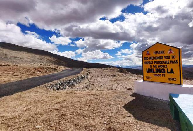
5793 m (19,005 ft) Umling La, (N32.6921 E79.2707), India (now the worlds highest asphalted road [asphalted in 2021] but military only - elevation often subject to false inflated claims)
5787 m (18,986 ft) Mobdi La, (N34.4368 E79.2634) Tibet / Xinjiang
It should be noted that any attempt to categorise roads will result in some dispute. What is a road? Define a road. Does the road have to be in public use (i.e. not military only)? Does the road have to be currently maintained (and not derelict)? Some people like to use the word "motorable", which strikes me as a bit absurd. If there is a road, it is by definition motorable. It means motor vehicles do or did use it regularly. If they didn't, it wouldn't be a road in the first place. Well for the purposes of this exercise I am going to assume adventure seekers do in fact have some resourcefulness about them. There are many military only roads that members of the public manage to get permission to ride. There are many unmaintained or derelict roads that some vehicles struggle to pass while lighter more agile bikes, or bikes with more skilled riders do manage to pass. So we are going to interpret this broadly.
A final warning. Altitude kills. Hundreds of very fit, healthy people die from altitude sickness every year from venturing too high, too quickly. Acclimatisation is essential. Above 5,500m your body is slowly dying. TAKE IT SERIOUSLY.
Altitude sickness has three forms:
- A mild but important form known as AMS or Acute Mountain Sickness
- Swelling of the brain or HACE (high-altitude cerebral edema)
- Fluid on the lungs or HAPE (high-altitude pulmonary edema).
Acclimatizing to heights of 3,000m to 5,000m is much more difficult: at these altitudes it is absolutely essential to ascend slowly and return to a lower altitude to sleep if travelling around at a higher altitude during the day. Over 50 percent of people will become ill if they ascend rapidly from sea level to 3,500m without acclimatization, whereas almost everyone will get altitude sickness if they ascend rapidly to 5,000m without acclimatization.
It is believed to be impossible to remain well at heights above 5,500m without spending at least a week acclimatising. It is possible to spend several weeks sleeping as high as 6,000m once acclimatised, however, but gradual deterioration of physical well-being will still occur. The highest village in the world, La Rinconada, is at 5,100m (16,732 ft) and mountaineering basecamps for the world's highest mountains are in the 5,000-5,300 metre range, because if the body goes much beyond that altitude, it deteriorates and cannot recover until descending to that "base camp" altitude.
Death rates from altitude sickness above 7,000m are estimated at 4 percent of all people who venture that high - thats even more dramatic when you realise that almost everyone who even gets to 7,000 metres in the first place is very fit, very healthy, very strong, and very well prepared, with excellent gear. Yet still 1 in 25 will die from altitude sickness.
And so to the roads ... (drop me a line at wcolebatch@gmail.com if you know of a road to add to this, as it will be an ongoing work in progress. In some areas such as Tibet and India new high roads are being carved thru the Himalaya regularly, mainly as part of defense related projects - observation posts. Artillery parking lots etc. Images even 3-4 years old are out of date)
Nota Bene: One of the reasons for compiling this list is there is so much false information on the internet from propaganda generators such as this following link, that claim the 8 worlds highest passes are all in India (when I have none in my list of the top 10) ... Its like they have conveniently chosen to forget that the rest of the world including the generally higher Tibet right next door, let alone all of Latin America, even exist. It's nothing but badly researched propaganda.
http://www.walkthroughindia.com/walkthroughs/worlds-8-highest-motorable-roads-india/
And while we are on the topic of fake news, one does need to have a fair bit of skepticism regarding the "claims" of the elevation of a high road, particularly those coming from an Indian source unfortunately. Elevations in India (both on official road signs and published maps) are often inflated to ridiculous levels, sometimes by as much as 300m /1000 feet. The most glaring example was Khardung La which was claimed in India to be 1) the highest road in the world and 2) 5,602m / 18,380 feet until a year or so ago, when it was finally accepted as being blatantly false. The altitude references have mostly been taken down now that it is widely known as being 5,359m [edit: recent sources have told me there are new signs at Khardung La post 2019 yet again claiming the misleadingly false 18380 feet].
I am yet to complete my survey of high passes and roads around the world, but while many sources in India are still claiming Khardung La as the worlds second highest pass, my research shows it is not even be in the top 100 highest roads in the world (I have already found 100 roads higher than Khardung La and I am nowhere near finished looking). So do take road signs with a BIG pinch of salt and scepticism, especially in India.
.png)
All the elevation data I am using is cross checked to make sure it is consistent with the STRM data.
THE HIGH ROADS
6176 m (20,262 ft) Aucanquilcha, (S21.2209 W68.4685) Chile (abandoned mining road, debris slides)
5980 m (19,620 ft) Volcan Tacora, (S17.7204 W69.7727) Chile (needs confirmation)
5945 m (19,505 ft) Chamkang Pass, (N34.4200 E79.2336) Tibet / Xinjiang
5902 m (19,364 ft) Refugio Tejos access road, (S27.0906 W68.5396) Chile (Regular use by standard 4WDs)
5900 m (19,357 ft) Yangi Daban, (N35.6455 E79.6365) Xinjiang
5885 m (19,307 ft) Kyapsang La / Yiyepusang La, (N34.4036 E78.9945) Xinjiang
5835 m (19,144 ft) Lhagang La, (N32.53874 E79.41393) Tibet (military post)
5830 m (19,127 ft) Lajiong La / Sawo La, (N30.1395 E85.1074) Tibet
5829 m (19,124 ft) Jing La, (N28.9172 E84.9537) Tibet (one way road up a hill)
5825 m (19,111 ft) Buduo La, (N31.2666 E79.3661) Tibet (new road)
5815 m (19,078 ft) Volcan Uturuncu, (S22.2581 W67.1787) Bolivia (former mine access road - access to 5900 possible)
5808 m (19,055 ft) WenQuan Daban Pass (34.4942 E79.0975) Xinjiang
5793 m (19,005 ft) Umling La, (N32.6921 E79.2707), India (now the worlds highest asphalted road [asphalted in 2021] but military only - elevation often subject to false inflated claims)
5787 m (18,986 ft) Mobdi La, (N34.4368 E79.2634) Tibet / Xinjiang
5780 m (18,963 ft) XiaRang La, aka Jang Rang La / Shangrang La (N32.0499 E78.8906) Tibet
5779 m (18,960 ft) Volcan Putana (S22.5561 W67.8559) Chile, former mine access road
5773 m (18,940 ft) Kungzhag La, (N28.0838 E88.58735) India (Sikkim) (military road)
5767 m (18,920 ft) Bodpo La, (N31.3136 E78.9826) Tibet
5765 m (18,914 ft) Zusong La, (N30.4633 E84.6082) Tibet
5763 m (18,907 ft) Zalong Sheqiong, (N30.0559 E85.3538) Tibet
5760 m (18,897 ft) Volcan Ollague (S21.2997 W68.1771) Chile, former mine access road
5755 m (18,881 ft) Huoshaoyun Mine Road (N34.6039 E79.1510) Xinjiang, mining road
5745 m (18,848 ft) Ouerji La, (N30.4595 E84.6273) Tibet
5735 m (18,816 ft) Sairecabur Telescope / Mining Road (S22.7267 W67.8808) Chile / Bolivia
5702 m (18,707 ft) Kiu La, (N34.0513 E78.6611) Tibet (military observation post)
5700 m (18,701 ft) Volcan Acotango, (S18.3707 W69.0502) Bolivia / Chile, mine access road
5698 m (18,694 ft) Jiabuxi La (N30.92105 E82.8965) Tibet
5691 m (18,671 ft) Volcan de Azufre (S21.7882 W68.2417) Chile, abandoned mining road
5685 m (18,652 ft) Hongqi Daban, (N34.5226 E79.1493) Xinjiang
5682 m (18,642 ft) Zulung La (N32.5417 E79.2738) Tibet (military post)
5676 m (18,622 ft) Black Peak (Qiudjianke) (N33.6229 E77.7735) Tibet (military post)
5642 m (18,510 ft) Changlung La (N34.5822 E78.7932) Xinjiang
5639 m (18,500 ft) Zezhang Mine Road (N29.7222 E86.2015) Tibet
5638 m (18,497 ft) Suolang La (N32.5145 E79.4231) Tibet
5631 m (18,474 ft) Gurudongmar Peak (N28.0311 E88.7282) India (Sikkim) Military observation post
5629 m (18,467 ft) Cerro Canapa (S21.4979 W68.0971) Bolivia, former mine access road
5628 m (18,464 ft) Tokyo Atacama Observatory (S22.9864 W67.7422) Chile, operational Observatory
5622 m (18,445 ft) Curiquinca (S22.61055 W67.5890) Chile / Bolivia, former mine access road
5616 m (18,425 ft) Hongpinshan, (N35.1871 E78.2886) Xinjiang
5611 m (18,409 ft) Mana Pass, (N31.0697 E79.4148) India / Tibet, (military only)
5610 m (18,405 ft) Manshan Mine Access (N34.6467 E79.1214) Xinjiang
5587 m (18,330 ft) Charding La, (N32.5236 E79.4066) Tibet (military post)
5586 m (18,327 ft) Sese La Outpost, (N28.03095 E88.80345) India (Sikkim) (military post)
5585 m (18,323 ft) Changlung Pantung La (N34.5755 E78.6831) Xinjiang
5582 m (18,313 ft) Marsimik La, (N34.0934 E78.6180) India (elevation often subject to false inflated claims)
5579 m (18,304 ft) Tianhedong Daban, (N35.14534 E78.3107) Xinjiang
5576 m (18,294 ft) Lo La (N29.9094 E86.70715) Tibet
5573 m (18,284 ft) Cho Oyu Basecamp Road (N28.1547 E86.5998) Tibet
5572 m (18,281 ft) Yu La, (N29.9435 E84.4509) Tibet
5570 m (18,274 ft) Wuersisan Radome Road (N35.3100 E78.3104) Xinjiang
5565 m (18,258 ft) Semo La, (N30.1099 E85.4317) Tibet (Highest asphalted road open to public, regularly used by trucks and buses)


WORLD'S HIGHEST PAVED ROAD?
There are claimants for the worlds highest paved road as diverse as Pakistan - Khunjerab Pass (4693m) and Peru - Mirador de los Andes (4875m - sometimes incorrectly claimed to be 4950m) all thousands off feet below the highest paved roads in the world - until very recently the worlds highest paved road was actually in Tibet. 5565 m (18,258 ft) Semo La, (N30.1099 E85.4317) was until 2021 the worlds highest paved road.
5565 m (18,258 ft) Semo La, (N30.1099 E85.4317) Tibet (Highest asphalted road open to public, regularly used by trucks and buses)


Above pics taken at the 5808m high WenQuan Daban Pass

Picture above is taken at Refugio Tejos, a climbers camp (made from 2 bright orange 20 foot shipping containers) on the slopes of Ojos del Salado in Chile. The Tejos Refugio is at 5823m and is accessible by regular 4WDs, as pictured above. In fact the motorable road goes higher than Tejos, allowing climbers to be dropped off at a loop at 5902 metres. The pic below for example (showing 5848 metres) is taken on the road above Tejos

WORLD'S HIGHEST PAVED ROAD?
There are claimants for the worlds highest paved road as diverse as Pakistan - Khunjerab Pass (4693m) and Peru - Mirador de los Andes (4875m - sometimes incorrectly claimed to be 4950m) all thousands off feet below the highest paved roads in the world - until very recently the worlds highest paved road was actually in Tibet. 5565 m (18,258 ft) Semo La, (N30.1099 E85.4317) was until 2021 the worlds highest paved road.

In early August 2021 India's Border Roads Organisation (BRO) paved the military only dirt road it had built in 2017 over Umling La (5793 m / 19,005 ft) giving us a new world's highest paved road. It is still military only, with special access permits required that unfortunately are not given to foreign nationals. Of course the altitude on their signs is inflated which is why no one who does ride there will actually show a picture of their GPS device or phone actually reading the claimed 19,300 feet (which is actually the height of a small peak near the pass) because their GPSs all read about 100m (300 feet) lower than the claimed altitude. And thats because it actually is about 100m lower - as a matter of fact.
WORLD'S HIGHEST FUEL STATION?
There is a place in Kaza in the Spiti Valley in India (N32.22763 E78.06996) which claims to be the world's highest fuel station at 3740m (12,270 feet), but knowing what we know about Indian altitude claims, this is of course false in every possible way.


Firstly, the altitude is (yet again - par for the course) exaggerated. It is not at 3740m, but STRM topography data shows the fuel station at Kaza to be at 3660m (12,007 feet). And of course that is not the highest fuel station in the world. There are literally hundreds and hundreds of higher fuel stations in Tibet, Peru, Bolivia, several of which are over 1000 metres (well over 3000 feet) higher than the one in Kaza. The tiniest bit of common sense and logic for example would immediately flag Potosi for example, a major city in Bolivia of around 200,000 people, at an altitude of 4100m and there are many, many fuel stations in Potosi servicing that considerable population. El Alto, the plateau suburbs of the Bolivian capital La Paz, is also at 4100+m and has a million people living there and all the countries major highways running thru there. Again, El Alto is serviced by literally dozens and dozens of fuel stations. To even contemplate a claim that 3660m would or even could possibly represent the worlds highest public fuel station, one would have to be totally ignorant of world geography.
4858m (15,938 feet) ... Wenquan, Qinghai Province, China is in the Guinness Book of Records as one of the highest permanent settlements on earth and unlike La Rinconada in Peru, Wenquan actually does have a fuel station as it is on a major highway (the G109 from Lhasa north to Qinghai). The fuel station in Wenquan is at 4858m accorting to STRM topographic data (via google earth screenshot below). N33.2231 E91.8563. Thats probably your highest fuel station in the world right there.
.jpg)
.jpg)
.jpg)
STOP PRESS: A higher fuel station has come to light (thanks Jorge) in Tibet in a town called Shuanghu, at 4919 metres (16,138 feet) N33.18803 E88.83697. It checks out as a public fuel station both on satellite images and on OSM maps, and the altitude is confirmed with STRM data.
WORLD'S HIGHEST FUEL STATION?
There is a place in Kaza in the Spiti Valley in India (N32.22763 E78.06996) which claims to be the world's highest fuel station at 3740m (12,270 feet), but knowing what we know about Indian altitude claims, this is of course false in every possible way.


4858m (15,938 feet) ... Wenquan, Qinghai Province, China is in the Guinness Book of Records as one of the highest permanent settlements on earth and unlike La Rinconada in Peru, Wenquan actually does have a fuel station as it is on a major highway (the G109 from Lhasa north to Qinghai). The fuel station in Wenquan is at 4858m accorting to STRM topographic data (via google earth screenshot below). N33.2231 E91.8563. Thats probably your highest fuel station in the world right there.
.jpg)
.jpg)
.jpg)
.jpg)
While we are on the topic of dodgy Indian altitude records (and nearby to the Kaza fuel station claim), some of you may have come across this claim to be the worlds highest village - Komic in India (N32.23487 E78.11072), which by the way also claims to have the worlds highest accommodation and roadside restaurants, claims an altitude of 4587m (15049 ft). Of course if you actually go there, you will find Komic is actually lower at 4515m / 14813 ft - which is around 600 metres lower than the much larger town of La Rinconada in Bolivia - and of course the highest accommodation and restaurant claims are also ignorant of global geography, and therefore completely false.


BONUS MYTH BUSTER - WORLDS HIGHEST ROAD BORDER CROSSING
I bet you thought the highest border crossing in the world was the Khunjerab Pass between China and Pakistan at 4693m (15,397 ft) right? Cause you have read it on 200 peoples blogs and seen it on YouTube videos so it must be true.

Well if you actually take the time to look around and do some research there are higher ones!
Like for example, the Paso de Agua Negra [S30.19270 W69.82514] between Argentina and Chile on the Gabriela Mistral International Highway at 4780m (15,682 ft).

Also between Argentina and Chile is the Paso San Francisco [S26.87368 W68.29914] at 4726m (15,505 ft) that the Dakar has crossed several times, testing the riders and their bikes.

Now there a new candidate for worlds highest road border crossing. In 2017 the Chinese built a road over the border pass, Tipta La (N27.8155 E87.7355), to Olangchung Gola in far eastern Nepal. The pass is way up at 5095m (16,716 ft) which as far as I am aware, is the highest road border in the world. However ... having taken the road, and having arrived at the villages of far eastern Nepal (a 25km drive from the Tipta La Border), in the shadows of the worlds 3rd highest mountain, Kanchenjunga, you would not be able to drive / ride to the rest of Nepal. There are no roads there apart from the 25 km long Tipta La border road - though I am told the Nepalese have vague plans at some unknown time in the future (they were claiming by the end of 2020 but dates seem to have overrun) to connect the Tipta La road and Olangchung Gola with the rest of the Nepalese road network at Taplejung. (for more information see HERE: ) I think once that is done, then it can unequivocally be considered the highest road border crossing in the world. For now its a bit of an isolated oddity but, if you were a cyclist travelling light, you could cross the border from China, ride down to Olangchung Gola and then trek out, but cars and motorcycles (at least for now) would need to turn around and go over the pass and back to China. It's the only road in and the only road out. Fortunately, considering you would have to do the pass twice, the road to the pass is indeed spectacular:
.jpg)
The Lipulekh Case? Note, there is a road (on the Chinese side - but more of a walking track on the Indian / Nepalese side though I note the Indian Border Roads Agency has promised to turn the path to the Pass into a proper vehicle track - see pic below) up to a seasonal border crossing at Lipulekh pass (N30.2328 E81.0285) between India or Nepal (there is a small triangle of disputed territory the path crosses to China from) and China that is open in the summer months for the Kailash pilgrimage. Mount Kailash is a mountain sacred to both Buddhists and Hindus, and in summers where tensions between India and China are not too high, the Chinese open the crossing to pilgrims, but it is to travelers on foot only - the border, while serviced on the Chinese side by a road, (and in the near future India also plans to build a road up to the pass) is not a road border crossing and will still NOT be a road border crossing even after India builds a road up to the pass (the roads will meet but no vehicles will be allowed to cross. Foot passengers only. Further, the pass (which I have seen claimed at about 10 different heights in Indian sources, up to 5300m, is actually the same height as Tipta La, 5095m (16,716 ft)

I have been in Agua Negra and Paso San Francisco, as well as some other mountain passes between Chile and Argentina. The border is where military put it, and of course, the border crossing is there. But the border control is at lower altitude, and sometimes quite far away. In the case of San Francisco, border control is at Laguna Verde, 23 Km from the border, and 500 m lower
ReplyDeleteThe border is the line demarking one countries territory from the other. A border is not where the officials decide to put their post where they process facilities. The Khunjerab Pass border is at 4693m, but the Pakistani customs and immigration post is 50km down the road at Sost, at 2800 metres altitude. The Chinese immigration and customs post is at Taxkurgan at 3100m. But it doesnt matter where the pakistanis and the Chinese put their facilities, the point is the border exists only in one place and that is at 4693m. Same goes for Chile and Argentina.
DeleteVery cool info
ReplyDelete